CLIMA
18 de enero de 2025
EL ALERTA METEOROLÓGICO PASÓ DE AMARILLO A NARANJA
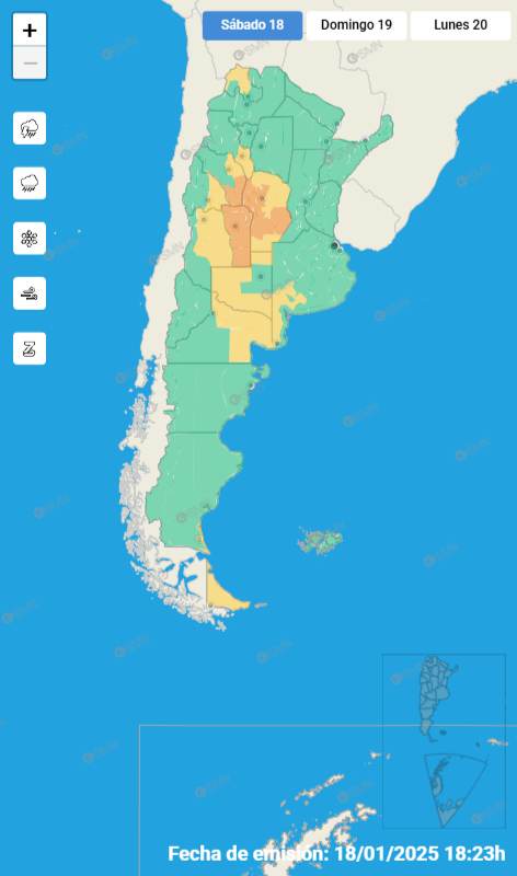
ASÍ LO INFORMÓ EL SERVICIO METEOROLÓGICO NACIONAL

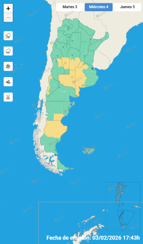
Desde el Servicio Meteorológico Nacional, se informó que el alerta por tormentas para nuestra región pasó del amarillo al naranja.
En el área de cobertura están los Departamentos Unión, Marcos Juárez y General San Martín.
INFORME:
Alerta por tormenta
Naranja:
El área será afectada por tormentas fuertes o severas. Las mismas estarán acompañadas principalmente por ráfagas que podrían superar los 90 km/h, caída de granizo, fuerte actividad eléctrica y abundante caída de agua en cortos períodos. Se prevén valores de precipitación acumulada entre 40 y 80 mm, pudiendo ser superados en forma puntual.

COMPARTIR:
Notas Relacionadas


Comentarios

| OFICIAL COMPRA | OFICIAL VENTA |
|---|

30.9°C
A Río Cuarto:
Lunes a viernes:
9:500 – 12:55 – 15:25 – 18:40 – 20: 40
Sábados, domingos y feriados:
9:50 – 12:40 – 17:40
A Corral de Bustos:
Lunes a viernes:
2:55 – 8:20 (hasta Arias) – 11:55
Lunes, jueves y viernes:
15:35 – 18:40 – 19:05 – 22:05
Sábados, domingos y feriados:
2:55 – 8:20 – 11:55 – 15:35 – 20:50
A Córdoba:
Lunes a viernes:
3:15 (Expreso) – 5:15 (Local)
Lunes, jueves y viernes:
16:15
Sábados, domingos y feriados:
5:15 (Local) – 16:15 (Sábados hasta Villa María – Domingo a Córdoba)
LOS TURNOS COMIENZAN A LAS 08:00 HS. DEL DÍA INDICADO Y FINALIZAN A LAS 08:00 HS. DEL DÍA SIGUIENTE.
Febrero de 2026:
Lunes 2: Tenor
Martes 3: Príncipe
Miércoles 4: Albizuri
Jueves 5: Muñóz
Viernes 6: Mazzola
Sábado 7: Muzzio
Domingo 8: Caverzán
Lunes 9: Sabarich
Martes 10: Príncipe
Miércoles 11: Tenor
Jueves 12: Príncipe
Viernes 13: Albixuri
Sábado: 14: Muñóz
Domingo 15: Mazzola
Lunes 16: Muzzio
Martes 17: Manochio
Miércoles 18: Sabarich
Jueves 19: Caverzán
Viernes 20: Tenor
Sábado 21: Príncipe
Domingo 22: Albizuri
Lunes 23: Muñóz
Martes 24: Mazzola
Miércoles 25: Muzzio
Jueves 26: Manochio
Viernes 27: Sabarich
Sábado 28: Caverzán
Números útiles:
* Hospital: 107 - 471442
* Bomberos: 100 - 473500
* Policía 101 - 472078
* Defensa Civil: 103
* Guardia Urbana: 3468516164
* Guardia Policía: 3468615912

Buscar en Monte Maíz

Sagitario
Día decisivo para ciertas actividades que desarrollas. Deja el nerviosismo de lado, todo saldrá a pedir de boca. Notarás como la relación en la que te encuentras actualmente crece fuerte y sólida. Disfruta del amor en tu vida. Jornada francamente espectacular a nivel laboral. Todo se desarrollará en relación a tus planes y saldrá a pedir de boca.Sugerencia: No puedes contar todos los días con una energía irrefrenable. Toma las cosas con un poco más de calma en la jornada de hoy, con tiempo todo mejorará.