CLIMA
21 de octubre de 2023
ALERTA METEOROLÓGICO PARA NUESTRA REGIÓN
TORMENTAS FUERTES Y SEVERAS
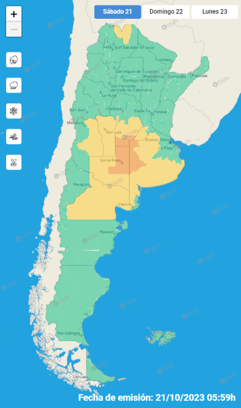
El SMN (Servicio Meteorológico Nacional) emitió un alerta amarillo por tormentas fuertes para hoy y un alerta naranja por tormentas severas para el domingo.
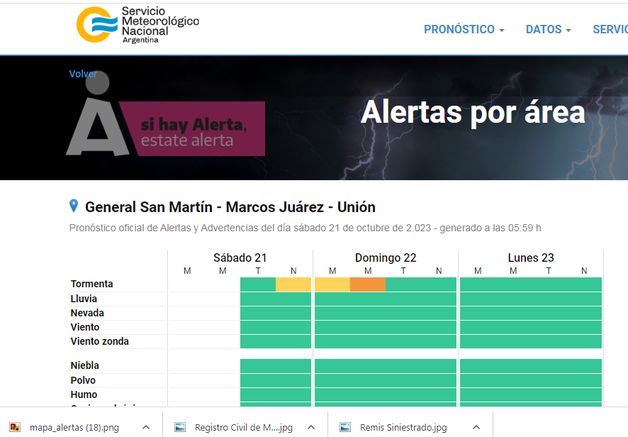
Eb el +área de cobertura figuran el Departamento Unión, Marcos Juárez y General San Martín.
Informe SMN:
Alerta por tormenta
Amarillo:
El área será afectada por lluvias y tormentas de variada intensidad, algunas localmente fuertes. Se espera que las mismas estén acompañadas por intensas ráfagas, fuerte actividad eléctrica, caída de granizo y abundante caída de agua en cortos períodos. Se estiman valores de precipitación acumulada entre 15 y 40 mm, pudiendo ser superados en forma puntual.
Naranja:
El área será afectada por lluvias y tormentas de intensidad fuerte o localmente severa. Las mismas pueden estar acompañadas por caída de granizo, ráfagas intensas, fuerte actividad eléctrica y abundante caída de agua en cortos períodos.
Se esperan valores de precipitación acumulada entre 40 y 90 mm, pudiendo ser superados de manera local.
.png)
COMPARTIR:
Notas Relacionadas

PRONÓSTICO EXTENDIDO PARA LOS �PRÓXIMOS SIETE DÍAS
MICRO INFORMATIVO DE LA COOPERATIVA AGRÍCOLA DE MONTE MAÍZ LTDA.
PRONÓSTICO EXTENDIDO PARA LOS PRÓXIMOS SIETE DÍAS
MICRO INFORMATIVO DE LA COOPERATIVA AGRÍCOLA DE MONTE MAÍZ LTDA.
PRONÓSTICO EXTENDIDO PARA LOS PRÓXIMOS SIETE DÍAS
MICRO INFORMATIVO DE LA COOPERATIVA AGRÍCOLA DE MONTE MAÍZ LTDA.Comentarios

| OFICIAL COMPRA | OFICIAL VENTA |
|---|---|
|
$ 1.377,84
+$ 0,30 |
$ 1.431,22
+$ 0,31 |
| BLUE COMPRA | BLUE VENTA |
|
$ 1.365,00
Igual |
$ 1.410,00
Igual |

20.5º
A Río Cuarto:
Lunes a viernes:
9:500 – 12:55 – 15:25 – 18:40 – 20: 40
Sábados, domingos y feriados:
9:50 – 12:40 – 17:40
A Corral de Bustos:
Lunes a viernes:
2:55 – 8:20 (hasta Arias) – 11:55
Lunes, jueves y viernes:
15:35 – 18:40 – 19:05 – 22:05
Sábados, domingos y feriados:
2:55 – 8:20 – 11:55 – 15:35 – 20:50
A Córdoba:
Lunes a viernes:
3:15 (Expreso) – 5:15 (Local)
Lunes, jueves y viernes:
16:15
Sábados, domingos y feriados:
5:15 (Local) – 16:15 (Sábados hasta Villa María – Domingo a Córdoba)
LOS TURNOS COMIENZAN A LAS 08:00 HS. DEL DÍA INDICADO Y FINALIZAN A LAS 08:00 HS. DEL DÍA SIGUIENTE.
Mayo de 2026:
Martes 5: Albizuri
Miércoles 6: Muñóz
Jueves 7: Mazzola
Viernes 8: Muzzio
Sábado 9: Príncipe
Domingo 10: Sabarich
Lunes 11: Caverzán
Martes 12: Tenor
Miércoles 13: Príncipe
Jueves 14: Albizuri
Viernes 15: Muñóz
Sábado 16: Mazzola
Domingo 17: Muzzio
Lunes 18: Sabarich
Martes 19: Manochio
Miércoles 20: Caverzán
Jueves 21: Tenor
Viernes 22: Príncipe
Sábado 23: Albizuri
Domingo 24: Muñóz
Lunes 25: Mazzola
Martes 26: Muzzio
Miércoles 27: Manochio
Jueves 28: Sabarich
Viernes 29: Caverzán
Sábado 30: Tenor
Domingo 31: Príncipe
Números útiles:
* Hospital: 107 - 471442
* Bomberos: 100 - 473500
* Policía 101 - 472078
* Defensa Civil: 103
* Guardia Urbana: 3468516164
* Guardia Policía: 3468615912